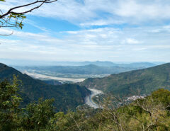
• Home
  • Taiwan Hiking Map
  • 現場錄音與音訊修復服務
  • About
    • About Me
    • Liability Disclaimer
  • Contact
  • Language Menu:  English
    • English  English
    • 中文 (台灣)  中文 (台灣)
Menu
  • Home
  • Taiwan Hiking Map
  • 現場錄音與音訊修復服務
  • About
    • About Me
    • Liability Disclaimer
  • Contact
  • Language Menu:  English
    • English  English
    • 中文 (台灣)  中文 (台灣)
Home  /  Taiwan Off-Roading  /  Xinhaocha Riverbed Ride to Sunken Church
19 March 2015

Xinhaocha Riverbed Ride to Sunken Church

Written by Glenn
Taiwan Off-Roading aboriginal cultural village, KLX250s, riverbed, Sandimen, sunken church, Taiwan, Xinhaocha Leave a Comment

Ride Info

This is a relatively easy ride down the riverbed near Sandimen to get to Xinhaocha village that was destroyed by typhoon Morakot. Only a sunken church remains. To get to the riverbed you can try and drive through the aboriginal cultural village here: 22.707003,120.652546 You’ll have to talk your way past the guard though. If that doesn’t work, or you’d like to have more of an adventure, it looks like you can enter here: 22.711343,120.643051 There appear to be a few places you can access the riverbed from there.

There will be a few river crossings before reaching the church. The first one is the toughest, though not so bad. Here: 22.7060366,120.6747684 The water was flowing pretty quick, despite the drought at the time. For the most part it didn’t go past the top of my boot, but towards the end I needed to stabilize myself and the water went over my boot.

The church is located here: 22.6902271,120.7098633 You can clearly see it in satellite view as of January 2015.


Ride Start:

22.7132507879287, 120.66028137691319


Date:

2015 Jan 22


Notes

  • If you try and get in through the aboriginal cultural village you’ll need to pay a parking fee to get in. There are local farmers and a house or two beyond the gates; I’m sure they don’t pay. You might be able to talk your way past the parking guys. Or just consider it a donation.


GPX Track Download Instructions: Click the track on the map to see the download link


Gallery

2015-01-23-10.33.25.jpg
2015-01-23-11.54.jpg
2015-01-23-11.58.jpg
2015-01-23-12.07.jpg
2015-01-23-12.10.jpg
2015-01-23-13.19-2.jpg
2015-01-23-13.19-3.jpg
2015-01-23-13.33.jpg
2015-01-23-13.35.jpg
2015-01-23-13.36.jpg
2015-01-23-13.38.jpg
2015-01-23-11.34.38

Liability Disclaimer

Please read the Liability Disclaimer before using any information within this post, page or any part of this website.

Share On
Share on Facebook
Share on Twitter
Share on Pinterest
Share on Reddit
 Previous Article Laochijia Riverbed and Mountain Ride
Next Article   Shaxi Lindau Trail – Before Guard Station

Related Posts

  • Exploring Abandoned Mountain Roads in Taiwan Along the Shaxi Forest Road (沙溪林道)

    November 18, 2024
  • Exploring an Abandoned Forestry Bureau Building

    July 15, 2024
  • WeiLiaoShan North Peak 尾寮山北峰 featured image

    WeiLiaoShan North Peak – 尾寮山北峰 Exploratory Route

    March 13, 2023

Leave a Reply Cancel reply

Hiking in Taiwan & Offroad Motorcycling

Audio Services

音訊修復與現場錄音服務

Recent Comments

  • Glenn on Taiwan HSR Recording Trip: High-Speed Rail Captures and Station Ambience
  • Zhen zhen on Taiwan HSR Recording Trip: High-Speed Rail Captures and Station Ambience
  • Glenn on Importing a Satellite Phone into Taiwan
  • Mark on Importing a Satellite Phone into Taiwan
  • Glenn on Hike to PingBuCuoShan, CaoShan, NanHuLuShan West Peak – 坪埔厝山, 草山, 南湖呂山西
TAIWAN RELATED OUTDOORS BLOGS & SIMILAR TOPICS

Categories

PRIVACY POLICY

Tip Jar / 小費罐

Find something useful? Click the jar to buy me a coffee or send a little more to help with my hosting costs, or heck, why not a shit ton of cash to buy me a new motorcycle!? But really, any amount is GREATLY appreciated!

覺得內容有用嗎?點擊罐子請我喝杯咖啡,或多給一點幫我支付主機費用,或者,幹嘛不來一大筆現金讓我買台新摩托車!?……選擇在你。但說真的,任何金額我都超感謝!

Copyright © 2026 by outrecording.com. All Rights Reserved. Please read this Disclaimer / Privacy Policy before using any information on this site.

  [Valid RSS]